Centre of Hurricane Lee to pass west of Bermuda
The US National Hurricane Center (NHC), in its latest update, says Hurricane Lee is now about 245 miles southwest of Bermuda.
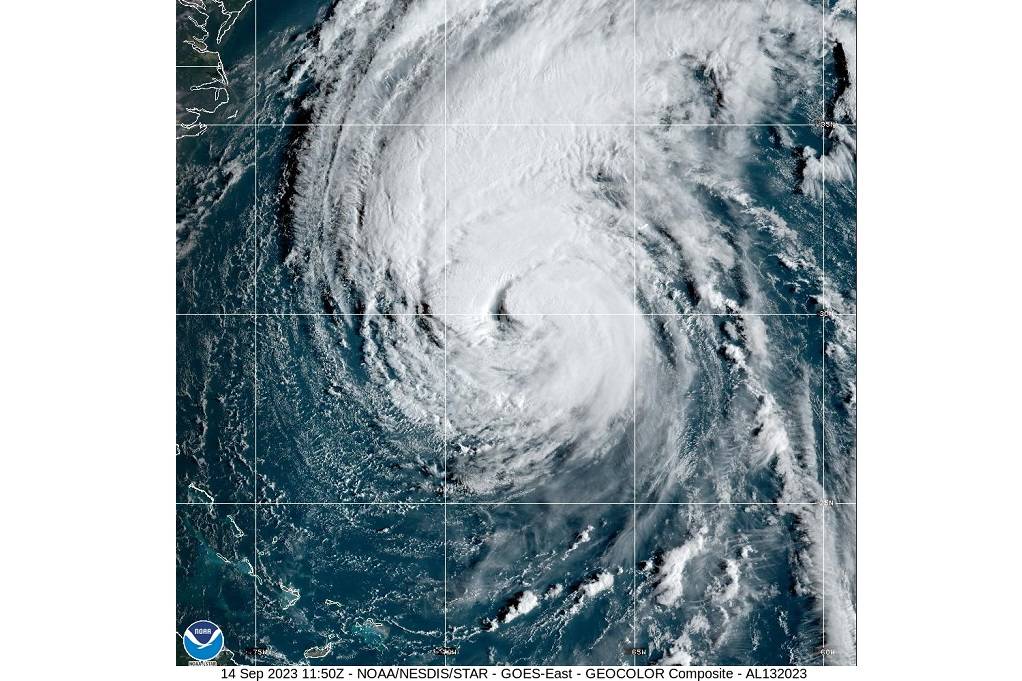
In its 11 a.m. update, NHC said Lee is moving toward the north near 14 mph (22 km/h), and this general motion with an increase in forward speed is expected through Saturday.
A turn toward the north-northeast and northeast is forecast for Saturday night and Sunday. On the forecast track, the centre of Lee will pass west of Bermuda today and tonight, approach the coast of New England and Atlantic Canada Friday and Saturday, and move across Atlantic Canada Saturday night and Sunday.
Data from Air Force Reserve and NOAA reconnaissance aircraft indicate that the maximum sustained winds are near 90 mph (150 km/h) with higher gusts. Weakening is forecast, but Lee is expected to remain a large and dangerous hurricane for the next few days.
Lee is a large hurricane. Hurricane-force winds extend 90 miles (150 km) from the center, and tropical-storm-force winds extend outward to 310 miles (500 km).
A wind gust of 48 mph (78 km/h) has recently been reported at the L.F. Wade International Airport in Bermuda.
NOAA buoy 41048, located about 130 miles (210 km) northwest of the centre of Lee, has recently reported a peak one-minute sustained wind of 54 mph (86 km/h) and a gust of 67 mph (107 km/h)
The following updates have been made on watches and warnings for Hurricane Lee:
A Tropical Storm Warning has been issued for the coast of Massachusetts from Woods Hole to Hull, including Cape Cod, Martha's Vineyard, and Nantucket. Summary of watches and warnings in effect: A Hurricane Watch is in effect for... * Stonington, Maine to the US/Canada border * New Brunswick from the US/Canada border to Point Lepreau, including Grand Manan Island * Nova Scotia from Digby to Medway Harbour A Tropical Storm Warning is in effect for... * Bermuda * Massachusetts coast from Woods Hole to Hull * Martha's Vineyard * Nantucket A Tropical Storm Watch is in effect for... * Watch Hill, Rhode Island to Woods Hole Massachusetts * Block Island * North of Hull Massachusetts to Stonington Maine * New Brunswick from north of Point Lepreau to Fort Lawrence * Nova Scotia west coast from north of Digby to Fort Lawrence * Nova Scotia southeast coast from north of Medway Harbour to Porter's Lake A Storm Surge Watch is in effect for... * Cape Cod Bay * Nantucket
Hazards Affecting Land from Lee:
WIND: Tropical storm conditions will continue on Bermuda through Friday. Hurricane conditions are possible in the Hurricane Watch areas in Down East Maine and Atlantic Canada on Saturday.
Tropical storm conditions are possible in the Tropical Storm Watch area in coastal New England and Atlantic Canada late Friday into Saturday. STORM SURGE: The storm surge and tide will cause normally dry areas near the coast to be flooded by rising waters moving inland from the shoreline. The water could reach the following heights above ground somewhere in the indicated areas if the peak surge occurs during high tide... Chatham, MA to Sagamore Beach, MA...2-4 ft Cape Cod Bay...2-4 ft Nantucket...2-4 ft Sagamore Beach, MA to Border of US/Canada...1-3 ft Boston Harbor...1-3 ft Flushing, NY to Chatham, MA...1-3 ft Montauk Point, NY to Flushing, NY...1-3 ft Long Island Sound...1-3 ft Martha's Vineyard...1-3 ft Rockaway Inlet, NY to Montauk Point, NY...1-2 ft The deepest water will occur along the immediate coast where large and destructive waves will accompany the surge. Surge-related flooding depends on the relative timing of the tide and the tidal cycle and can vary greatly over short distances.
A dangerous storm surge could produce coastal flooding within the wind watch areas in Atlantic Canada in areas of onshore winds. Near the coast, the surge will be accompanied by large and destructive waves.
SURF: Swells generated by Lee are affecting portions of the Lesser Antilles, the British and US Virgin Islands, Puerto Rico, Hispaniola, the Turks and Caicos Islands, the Bahamas, Bermuda, the east coast of the United States, and are beginning to reach Atlantic Canada. These swells are likely to cause life-threatening surf and rip current conditions.
RAINFALL: Outer rain bands from Lee could produce rainfall amounts of 1 to 2 inches, or 25 to 50 millimetres, across Bermuda today into early Friday. From Friday night through Saturday night, Lee is expected to produce rainfall of 1 to 4 inches, or 25 to 100 millimetres, across portions of eastern New England into portions of New Brunswick and Nova Scotia. This could produce localised urban and small-stream flooding.


0 Comment