Floods hit central, north Trinidad
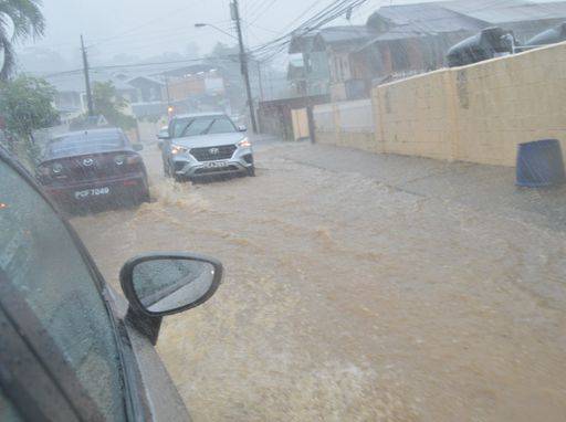
Floodwaters inundated Parts of Central and Northern Trinidad on Monday afternoon after multiple thunderstorms.
Shortly after midday, the skies erupted over Central Trinidad with intensifying showers as activity drifted north. The heaviest rains fell along the East-West Corridor, with upwards of 2.5 inches (63.5 millimetres) of rainfall accumulating for two to three hours.
Street and flash flooding was reported along the Eastern Main Road in, St Augustine, Mt Hope, Champs Fleurs, Barataria and Lavantille. Flooding also impacted several homes in Mt Lambert, an area that suffered severe flooding during Tropical Storm Karen in 2019.
Torrential rains moved gradually north-westward, with frequent, dangerous cloud-to-ground lightning.
On Monday, the Geostationary Lightning Mapper onboard the GOES-16 satellite detected 122 lightning strikes within five minutes.
Floodwaters quickly rose across the capital, with many low-lying streets in Port-of-Spain being flooded during the mid-afternoon, causing standstill traffic. As rains shifted further west, flooding spread to parts of North Port-of-Spain, Maraval, St Ann’s, Santa Cruz and Diego Martin.
Given street or flash floods, waters quickly subsided as rains eased. However, debris was still scattered on roads within Port-of-Spain and on the Lady Young Road, Morvant, which further hampered the free flow of traffic.
The Malick River, which passes through Morvant at Maritime Plaza, overflowed its banks and flooded the Priority Bus Route and the link road to the Churchill-Roosevelt Highway.
While the Diego Martin River reached near-threshold levels, it did not overflow as waters quickly moved into the Gulf of Paria.
This week, a complex trough system is forecast to maintain a volatile atmosphere across the country. The T&T Meteorological Service (TTMS) is forecasting a medium chance of thunderstorms today and tomorrow though no alerts, watches, or warnings are in effect for the country.
The forecast from the TTMS yesterday noted “partly cloudy to cloudy periods with occasional showers and rain over some areas interspersed by periods of sunshine. Storms will likely be heavy at times, and there is a 30- 40 per cent (low - medium) chance of an isolated thunderstorm.
The night will be partly cloudy with showers in a few areas.”
The Met Office added in their forecast issued on Monday afternoon for tomorrow that “gusty winds and street flooding can occur in the event of heavy showers or thunderstorms.”
Meanwhile, showers and thunderstorms that started moving across T&T yesterday are expected to continue throughout the week.


0 Comment