Floods Hit South, Central & Northern Trinidad
Heavy showers and thunderstorms flooded several parts of southern, central and northwestern Trinidad on Tuesday.
Starting in the south, significant street and flash flooding was reported along Papourie Road in the vicinity of Barrackpore East and West Secondary Schools. Water levels rose between two and three feet, rendering the roadway impassable for smaller vehicles through Tuesday afternoon
Persistent rainfall affected parts of central Trinidad, from Claxton Bay to Chase Village, from the late morning through early afternoon. Flooding was reported along Cedar Hill Road in Claxton Bay, which became impassable for smaller vehicles. Further north, flooding was reported in Couva, Balmain, St. Mary’s, Freeport, Chickland, Calcutta #1, #2, #3, McBean and environs as many smaller drains and streams were overwhelmed by the torrential rainfall. Flooding and fallen trees were also reported along interior areas of Central Trinidad, near Brasso Venado.
All southbound lanes of the Solomon Hochoy Highway were also impacted by flooding through the afternoon, causing a traffic pileup for commuters heading south.
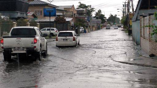
Further north, while early morning showers caused street flooding further east at Arouca on the Eastern Main Road, most of the flood reports occurred after midday across Port of Spain. Heavy rains and thunderstorms flooded many areas of lower Port of Spain, with street flooding reported across the capital. High flood waters prevented motorists from traversing South Quay and parts of Wrightson Road on Tuesday afternoon. The Ministry of Rural Development and Local Government stated Tuesday afternoon that flash flooding was taking place at South Quay and George Street, Port of Spain and advised the population of possible increased traffic in surrounding areas.
Flooding was reported in Belmont, Lavantille, along the Eastern Main Road and Saddle Road, Maraval. The Maraval, East Dry (St. Ann’s), and Diego Martin rivers were all elevated but remained within their banks on Tuesday afternoon.
While there were no alerts, watches or warnings in effect from the Trinidad and Tobago Meteorological Service, their official forecast issued at 10:06 AM on Tuesday warned of gusty winds and street flooding in the event of heavy showers or thunderstorms. Their full forecast for this afternoon and tonight called for, “Partly cloudy periods with showers over some areas will interrupt sunny conditions. There is a 40-60% (medium) chance of heavy showers or isolated thunderstorm activity, especially over parts of south Trinidad. Partly cloudy night with a few showers.”
Today’s showers and thunderstorms were due to a mix of weather features. The Intertropical Convergence Zone has drifted near Trinidad, and Tobago pulled northward due to a weak low-level trough, which brought rainfall to the country since Monday night. However, the late morning and afternoon showers and thunderstorms Trinidad experienced took advantage of the local climatic effects we typically see during the Wet Season. Namely, sea breeze convergence as moist air moves in from the Gulf of Paria, colliding with the prevailing easterly winds and rising, as well as daytime heating as light winds heat the ground, forcing moist air to rise.
The Met Office is also monitoring an approaching tropical wave. In a social media post, they said, “The next tropical wave is approximately 1220 kilometres to the east of the Lesser Antilles. The axis of this wave is forecast to reach the islands on Wednesday morning. Most of the moisture associated with this wave is expected to pass north of Trinidad and Tobago. However, we can still expect partly cloudy to cloudy conditions at times and a medium chance of thunderstorms in a few areas.”


0 Comment